Tuesday, October 9, 2012

Mohawk Lakes

Just past my house is a dirt road that leads to a rock road. At the end of the rock road is a trail that leads to Lower and Upper Mohawk Lakes. It is a short 2 mile hike to the upper lake, but it will get your heart rate going. Along the way there is old mining equipment and a beautiful waterfall. My first attempt at getting to the upper lake was unsuccessful. I started out in April and was blocked by giant snow drifts just after reaching the lower lake.
 There was a village of old run down cabins. This is one of them.


Here the lower lake is frozen.
This was my sad attempt to hike through the snow drift only to realize I still wasn't going to make it to the upper lake. So I slid down on my jacket
I also encountered signs of Bigfoot!


Here is a before and after of the waterfall:


And the second attempt I made it to the upper lake!!

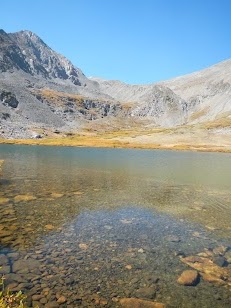
And an excellent look back at the lower lake

Tuesday, October 2, 2012

My first geocache

Geocaching is the sport of finding hidden objects using gps coordinates. There is a wonderful app for your phone called cgeo that I used. I went for a hike around my house and found Maggie's Cache on peak 9 in Breckenridge, co.


Tuesday, September 25, 2012

Crystal Lakes

Just on the back side of Peak 10 when you look to the south there is a valley with a lake in it. The lake is Crystal Lake and can be accessed by hiking or off-roading. The trail starts off pretty rocky and a bit of a climb. Once you get into the valley it opens up and is dirt until you get to the lake. The lake is beautiful and surrounded by mountains. The south mountain when you look at it has a few mine shafts. It is quite a hike through a scree field. The drive down was a prefect opportunity to see all the beautiful aspens changing.


Sunday, September 16, 2012

Triathlon

I competed in a triathlon last week. Here are some pictures!


I won my age group!

Tuesday, September 4, 2012

Eccles Pass

Hiking the Gore Range
We started in Frisco and started on the Meadow Creek Trail and met up with the Gore Range Trail. At the intersection of the two trails the moon was just visible in between two peeks.

Looking just to the right of my head you see a saddle. That is Eccles Pass and our final destination.

 Here is a zoomed in picture of Eccles Pass.
This is the back side of Buffalo Mountain. You see the front every time you are in Silverthorne or Dillon. 

Another view from the top of Eccles Pass. The craggy Gore Range. If you head to the west you will be in Vail. 

 Here with my roommate.
Hiking down we had a good view of lake Dillon.

Saturday, August 11, 2012

Is this cheating?

In the last few months I have been shown a new activity. It is called Jeeping or wheeling. I use to think that walking or biking was the only way to the top of a mountain. I have been proven wrong. A vehicle can make it to the top as well. 

This first picture is from the top of Peak 10 looking down the Tenmile Range. The Gore Range is visible in the distance, a little more jagged and rocky than the Tenmile Range. Breckenridge Ski Resort is just to the right and off the picture. We drove on Peak 9 and 10, so were driving where we snowboard in the winter. 


It's the beginning of August and the temperature is already starting to drop. It was cold up there. 


The Jeep that made it to the top! And the town of Breckenridge just visible to the left. 


This is the trail we drove up. Lake Dillon in the back and Highway 9 into Breckenridge.


We watched the sunset, then drove back down. The town was lit up and quite beautiful as we made our descent.


This was much easier than hiking. I got to take in some amazing views! But I'll leave it up to you whether it is cheating to drive to the top?